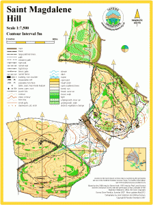
St Magdalenes Hill

Local event
Sun 25th Sep 2016
Last updated: 25th Sep
Type of event: Local
Type of terrain: Woodland
Read more about the mapped area
Results
Info
Great day today at Perth's St Magdalene's Hill. See the results and read organiser Bill Melville's report.
"Everyone seemed to have a good time at our event today. I would like to say thanks to you for coming along and making the work worthwhile and I would like, on your behalf, to thank all the officials and helpers who made it a success. A special thanks go to Jim Martin and Gillian Martin (both local Edinburgh Southern club members) who planned the event, put out the controls and helped with the follow up to the planning on the day." Bill Melville (Organiser)
Location
Nearest town: Perth
- Grid Ref: NO108212
- Postcode: PH2 0AR
- Latitude: 56.37845
- Longitude: -3.43977
- Google Map (aerial)
- Bing Map (OS)
- OpenStreetMap
Pre event information
Directions / Parking
Main public car park off Glendevon Road.
Access from Edinburgh Road A912 via Gleneagles Road (look out for "orienteering" sign). From south - at first road, turn to left. From Perth - turn right 150m after roundabout by Tesco Edinburgh Road. At the school, take left fork up Glendevon Road to top of the hill. For the parking - turn left.
Registration & Start Times
Registration: from 10.30 to 12.30.
Starts: 11.00 to 12.30.
Course Information
Yellow (1.3km 60m climb) - suitable for juniors and beginners.
Orange (1.9km 100m climb) - suitable for juniors and beginners.
Green (4.0km 160m climb) course is more challenging.
All courses subject to final planning.
Full leg cover strongly advised as the undergrowth is high and heavy.
Explanation of colour courses
- White are very easy with all controls on paths. They are mainly used by 6-10 year olds and family groups.
- Yellow use simple linear features like paths, walls and streams. They are mainly used by under 12’s and family groups.
- Orange progress to basic use of the compass and route choice. They are ideal for novice adults or experienced youngsters.
- Light Green are ideal for improvers as the navigational difficulty begins to increase and uses simple contours and point features.
- Green are used mostly by experienced under 18’s and adults wanting a short but challenging course with a very hard navigational difficulty.
- Blue are a longer, more physically demanding course in comparison to the green. The distances are more varied between controls and the course attracts experienced orienteers.
- Brown & Black are very physically demanding and have a very hard navigational difficulty. They are for experienced orienteers only.
- Score means visiting as many controls as possible in any order in a specific time, like 45mins.
Entry Details
Adults £7; club and BOF members £5. Juniors and Students £3 non BOF; £2 BOF.
Phone/email Bill to guarantee pre-marked map, specifying which course you want to do/how many maps you require.
Contacts / Officials
Planner: Jim Martin (ESOC) 07873733835
Email: jj-martin @ hotmail.co.uk (remove spaces)
Organiser: Bill Melville (TAY)
Email: billmelville@ ogoroad.com (remove spaces)
Safety and Risk
A comprehensive risk assessment will have been carried out by the organiser, but participants take part at their own risk and are responsible for their own safety during the event.
Keep It Clean campaign - Forestry Commission Scotland
Our forests are at risk from tree pests and diseases. These can dramatically affect the health of our trees, upsetting the delicate ecosystem balance and devastating large areas of woodland.
Pests and diseases hitch a ride in mud and debris on shoes, paws and tyres, ending up in new forests. Here, they can spread rapidly in environments with no natural resilience.
Read more about this on the FCS website.
Privacy
When entering our events your name may appear in the results section of this website or in newspaper reports.
Read our privacy policy to see how we look after your personal data.