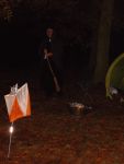
Tayside Orienteers
Mapped areas
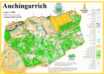
Auchingarrich
Near: Comrie
A classic mix of plantation forest, with a surprisingly intricate network of rides, and technically detailed open hillside, with some faster running on the fields and woodland of the valley floor to the north. Physically and technically very challenging, Auchingarrich hosted the Scottish Championships in 2011.
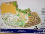
Balgay Park, Dundee
Near: Dundee
A wooded hill with some steep slopes surrounded by parkland and and urban area
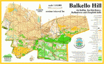
Balkello Hill
Near: Dundee
A varied area with extensive scattered quarry workings stretching over three main hills and one subsidiary hill. In the lower reaches, there is the Community Woodland with a network of paths, then an area with Scots pine woodland and varied open ground; then, higher, the largely open hill terrain in parts heathery and in parts providing good runnability.
Barry Buddon
Near: Carnoustie
A large mainly open area, with small pockets of woodland, Barry Buddon is located to the north of the mouth of the River Tay, between Carnoustie and Monifieth. It is generally very flat but with several extensive and complex areas of large sand dunes, making for very fast running but technically challenging orienteering.
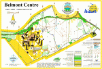
Belmont
Near: Meigle
A small mapped area of very flat, runnable pine woodland and the grounds of the Belmont Centre.
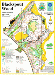
Black Spout
Near: Pitlochry
Black Spout is a small but very pleasant wooded area of generally southwest-facing slopes above the Blair Athol Distillery (in Pitlochry!). Dissected by two deep valleys, it provides some challenging contour detail and a good network of paths.
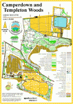
Camperdown Park and Templeton Woods
Near: Dundee
An easily accessible and very runnable mix of parkland, deciduous and coniferous woodland on the northwest edge of Dundee.
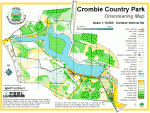
Crombie
Near: Carnoustie
Crombie Country park is an area of coniferous forest, of varying levels of runnability, surrounding Crombie Reservoir. There is a path right round the reservoir and across the dam at the east end, and in the wooded areas to the north and south.
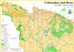
Culteuchar and Dron
Near: Forgandenny
A large, mainly open hill area with some of the best hill running in Perth and Kinross, expansive views and enjoyable orienteering. There is one fine iron-age hill fort. West Dron Hill lies on the east side of the map and is largely coniferous forest.
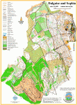
Dalguise and Sophia Woods
Near: Dunkeld
A challenging area, both technically and physically, at the north end of Craigvinean Forest, on the west side of the Tay valley. The mapped area includes the PGL Dalguise Outdoor Centre. Conifer forest of mixed density and runnability, rough in places, but with excellent orienteering in places.
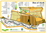
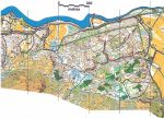
Den of Alyth
Near: Alyth
A popular local beauty spot - a deep, wooded valley running from West to East, with a network of paths and steep slopes. To the north of the Den, across a minor road, are the lower slopes of Hill of Alyth, consisting of fields and paths.
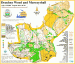
Deuchny and Murrayshall
Near: Perth
Deuchny is a Forestry Commission plantation, east of Kinnoull Hill, with some interesting contour detail and a complex path network, and Murrayshall Hill is a mix of rough open grassland and pockets of natural woodland, with great views to the north and south.
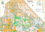
Drummond Castle
Near: Muthill
Delightful ancient oak woodland to the north of Drummond Castle dropping down to the Pond of Drummond, with mixed conifer woodland to the west complicated by linear volcanic dykes. Drummond Castle was used for the Scottish Relay Championships in 2011.
Dunalastair
Near: Kinloch Rannoch
A classic Highland mix of open moorland, plantation forest and natural woodland, with some very complex contour detail and very few line features, Dunalastair provides very technically and physically challenging orienteering.
Dunning Golf Course
Near: Dunning
Simple area for fun events in the village of Dunning south of Perth. Not to be used without permission.
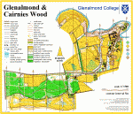
Glenalmond College
Near: Methven
Beautiful college grounds, largely playing fields but wooded slopes down to the River Almond, with a 9-hole golf course and conifer plantation to the south of the road. In the centre of the map is a fine quadrangle of college buildings.
Heart of Scotland
Near: Aberfeldy
An area close to the Birks of Aberfeldy where just over half is open land with good contour and rock detail, just under half is fully runnable conifer or birch woodland.
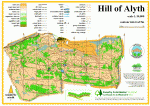
Hill of Alyth
Near: Alyth
An area of open hillside, with surprisingly complex contour detail, a good network of paths and an intricate pattern of gorse to add to the navigational challenge! Great views south over Alyth town towards Strathmore, and north to the foothills of the Grampian Mountains.
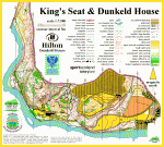
Kings Seat and Dunkeld House
Near: Dunkeld
A mix of birch, oak and coniferous woodland with some good contour and rock detail, plus open fields and the buildings of the Hilton Dunkeld House Hotel and Resort. The map covers a strip of land on the east bank of the Tay from the A9 bridge to the north to Dunkeld Abbey in the southeast corner.
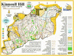
Kinnoull Hill
Near: Perth
One of our most popular areas - a mix of deciduous and coniferous woodland with an intricate path network. The southern edge of the maps is a line of steep crags; the area slopes downhill to the west and north, with pockets of interesting contour detail. Wonderful views over Perth from the top of the hill!
Knock of Crieff
Near: Crieff
A whaleback hill with lovely deciduous woodland in its western half and coniferous forest to the east, reduced in size as a result of recent clear-felling. On the open moorland area to the north, newly-planted trees are maturing and will add to the orienteering challenge. A good path network and fine views north to the Highlands and south over Strathearn.
Lendrick Muir
Near: Lendrick Muir Activity Centre
A compact map of a Scripture Union Scotland outdoor centre estate, with gently rolling mown grassland and a small wooded area with a path network. We're planning to extend the map to include further woodland.
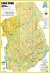
Loch Ordie
Near: Loch Ordie
Loch Ordie is a technically and physically challenging open area of moorland, covering a section of the eastern side of the Tay valley north of Dunkeld, plus a complex area of small hills at the top of the valley slope. There are parallel ridges, crags, boulders and marshes. Underfoot the terrain ranges from short sheep-grazed grass to deep heather, with few paths or line features. Loch Ordie itself lies to the south of the area, with Craig a'Barns beyond that. The area was first mapped for the 2009 Scottish 6 Days, when it hosted the 6th and final race.
Macrosty Park
Near: Crieff
A town parkland area, on the northwest edge of Crieff, om the banks of the Turret Burn.
Mill of Fortune
Near: Comrie
A long ridge generally running east-west, providing some challenging contour detail and an interesting mix of coniferous and deciduous forest along with small areas of open land. Mill of Fortune has been used in the past for a Scottish Orienteering League race.
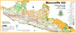
Moncreiffe Hill
Near: Perth
A long east-west hill with a variety of tree cover, much of it managed by the Woodland Trust. Moncrieffe Hill has steep southern flanks with crags very visible from the M90 motorway, and just a few ways down, but more gentle northern slopes which are a mix of open and wooded land offering good orienteering with an adequate path network. There are two iron-age hill forts in the area.
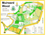
Muirward Wood
Near: Scone
A generally very runnable area of plantation forest north of Perth, with a good network of paths and ditches. The eastern half of the area, bordering Perth Airfield, is fairly flat, with the western part of the area consisting of fairly gentle south and west-facing slopes.
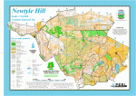
Newtyle Hill
Near: Dunkeld
To the south, Newtyle is mainly deciduous woodland or open with a small conifer area; to the west there is birch woodland with oak woodland in the northwest; to the north there is a Site of Special Scientific Interest (SSSI) area of juniper plus birch woodland; to the west the ground is more open and on the top there is heather, thick in places.
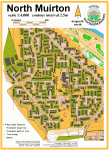
North Muirton
Near: Perth
A complex urban area, combining a detailed network of roads and paths through a modern housing estate and an area of riverside parkland.
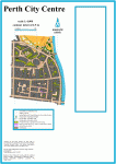
Perth City Centre
Near: Perth
City centre streets and lanes of Perth - used for the Final of the very successful Park World Tour Urban Sprint event in 2010.
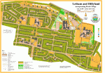
Perth College, Letham and Hillyland
Near: Perth
A new area for 2014, an urban / sprint area centred on the campus of Perth College. The map also includes three primary schools.
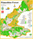
Pitmedden
Near: Abernethy
A technically detailed and very runnable mix of mature pine forest and open hillside, with a maze of paths and tracks, covering a ridge of land high above Abernethy. Fantastic views north across the Tay and south into Fife.
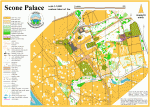
Scone Palace
Near: Perth
The estate of Scone Palace with a fine network of paths and a variety of terrain, including open ground beside the River Tay, the gardens of the Palace, the Pinetum with an eclectic range of tree types, and the Palace Maze for an added navigational challenge! Ideal for sprint orienteering.
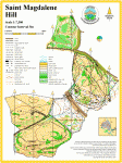
St Magdalene Hill
Near: Perth
St Magdalene Hill (St Mags for short) is a popular and easily accessible area on the southwest edge of Perth, covering a mix of parkland, mixed woodland and open hillside.
Strathallan School
Near: Forgandenny
Beautifully maintained school grounds with playing fields, a scattering of buildings, a wooded hill and dell, as well as a large pond.
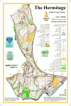
The Hermitage
Near: Dunkeld
The lower south east slopes of Craigvinean Forest, where there are the famous tourist attractions of Ossian’s Cave and the Hermitage, plus a folly and the Pinecone Viewpoint linked by a path network. The area is mainly open conifer woodland in the north with good rock detail.
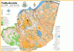
Tullochroisk
Near: Kinloch Rannoch
One of our very best areas. Stretching from the northern slopes of Schiehallion down to the River Tummel, Tullochroisk is classic Highland Scottish orienteering terrain - combining challenging open moorland with areas of natural deciduous woodland, and to the southwest, an area of mature, runnable coniferous plantation with excellent contour detail throughout.
Twenty Shilling Wood
Near: Comrie
A small, ancient oak woodland plus some conifer woodland providing delightful, quite hilly orienteering with the River Lednock cascading down its eastern edge.