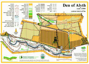
Den of Alyth

Location
Nearest town: Alyth
- Grid Ref: NO235487
- Postcode: PH11 8JX
- Latitude: 56.62779
- Longitude: -3.25260
- Google Map (aerial)
- Bing Map (OS)
- OpenStreetMap
Terrain description
A popular local beauty spot - a deep, wooded valley running from West to East, with a network of paths and steep slopes. To the north of the Den, across a minor road, are the lower slopes of Hill of Alyth, consisting of fields and paths.
This small map is very close to another of our mapped areas - Hill of Alyth. Both maps were produced with the support of the Alyth Hill Users Group.
Image Gallery
Click the image for a larger version.