Loch Ordie

Location
Nearest town: Loch Ordie
- Grid Ref: NO020510
- Postcode:
- Latitude: 56.63281
- Longitude: -3.59997
- Google Map (aerial)
- Bing Map (OS)
- OpenStreetMap
Terrain description
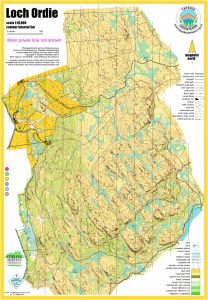
Loch Ordie is a technically and physically challenging open area of moorland, covering a section of the eastern side of the Tay valley north of Dunkeld, plus a complex area of small hills at the top of the valley slope. There are parallel ridges, crags, boulders and marshes. Underfoot the terrain ranges from short sheep-grazed grass to deep heather, with few paths or line features. Loch Ordie itself lies to the south of the area, with Craig a'Barns beyond that. The area was first mapped for the 2009 Scottish 6 Days, when it hosted the 6th and final race.
Image Gallery
Click the image for a larger version.

Looking from Loch Ordie towards the Tay and Schiehallion

Loch Ordie

Looking towards Deuchary Hill