Muirward Wood

Location
Nearest town: Scone
- Grid Ref: N0140280
- Postcode: PH2 6QF
- Latitude: 56.42884
- Longitude: -3.38717
- Google Map (aerial)
- Bing Map (OS)
- OpenStreetMap
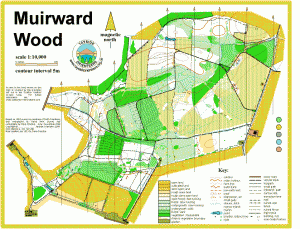
Terrain description
A generally very runnable area of plantation forest north of Perth, with a good network of paths and ditches. The eastern half of the area, bordering Perth Airfield, is fairly flat, with the western part of the area consisting of fairly gentle south and west-facing slopes.
Image Gallery
Click the image for a larger version.

Runnable woodland at Muirward

Muirward Wood