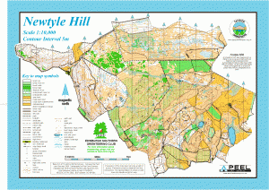
Newtyle Hill
Location
Nearest town: Dunkeld
- Grid Ref: NO063421
- Postcode: PH8 0JF
- Latitude: 56.55858
- Longitude: -3.51636
- Google Map (aerial)
- Bing Map (OS)
- OpenStreetMap
Terrain description
To the south, Newtyle is mainly deciduous woodland or open with a small conifer area; to the west there is birch woodland with oak woodland in the northwest; to the north there is a Site of Special Scientific Interest (SSSI) area of juniper plus birch woodland; to the west the ground is more open and on the top there is heather, thick in places.

The Newtyle map is jointly owned by Edinburgh Southern Orienteering Club (ESOC) and both clubs have put on events here.
Newtyle has also hosted a Scottish Orienteering League Event and the JK 2012 Relay Championships.
Image Gallery
Click the image for a larger version.
