Dalguise and Sophia Woods

Location
Nearest town: Dunkeld
- Grid Ref: NN991474
- Postcode: PH8 0JX
- Latitude: 56.60788
- Longitude: -3.64422
- Google Map (aerial)
- Bing Map (OS)
- OpenStreetMap
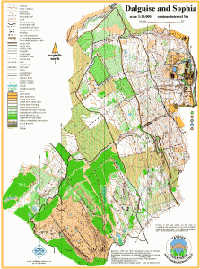
Terrain description
A challenging area, both technically and physically, at the north end of Craigvinean Forest, on the west side of the Tay valley. The mapped area includes the PGL Dalguise Outdoor Centre. Conifer forest of mixed density and runnability, rough in places, but with excellent orienteering in places.
There is a large height gain to get to the interesting open area around the top of Craigvinean, which in the last event held here (a South of Scotland Orienteering League) was incorporated by using a timeout section.
Image Gallery
Click the image for a larger version.