Pitmedden

Location
Nearest town: Abernethy
- Grid Ref: NO201150
- Postcode: KY14 7RX
- Latitude: 56.31354
- Longitude: -3.30135
- Google Map (aerial)
- Bing Map (OS)
- OpenStreetMap
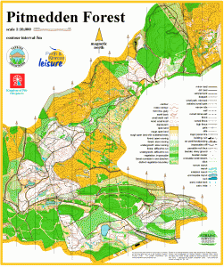
Terrain description
A technically detailed and very runnable mix of mature pine forest and open hillside, with a maze of paths and tracks, covering a ridge of land high above Abernethy. Fantastic views north across the Tay and south into Fife.
![]()
Pitmedden has hosted several full colour-coded events, including a South of Scotland Orienteering League Event and the Scottish round of the Compass Sport Trophy.
The Pitmedden map straddles Perthshire and Fife, and is jointly owned with Kingdom of Fife Orienteers. Events are held here by both clubs.
Image Gallery
Click the image for a larger version.

Winter in Pitmedden!